Risk Analysis Technology Research Group
Risk Analysis Technology
This group conducts research on risk assessment in a wide range of fields to improve the safety of ships.
Members
(◎: Head of the Group)
- Junichi KUDO
- Sonoko KAWASHIMA
- Rikako ASAUMI
- Megumi SHIOKARI(Concurrent post)
Research Overview
1. Development of evaluation models for the cargo spill, gas dispersion, and fire events due to an accident of a liquefied gas carrier
| In recent years, demands for liquefied natural gas (LNG) carriers have increased due to the growing demand for LNG. Therefore, there is an increasing concern about the risk of fire and gas dispersion caused by collision due to the increased marine transportation. In this study, we are developing consequence evaluation models and elemental technologies for assessing the risk of a liquefied natural gas carrier. |
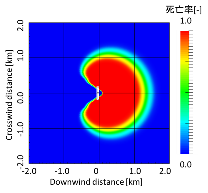 Fig.1 Estimated distribution of probability of fatality due to thermal radiation from a pool fire of cargo oil. |
|---|
2. Research on evaluation of the risk level of ships navigating in the coastal area
The partial expansion of the coastal area is expected to enable ships to reduce fuel consumption by shortening sea routes and avoiding dangerous sea areas. On the other hand, there are concerns about whether the safety of vessels navigating in the expanded area will be maintained.
In this research, we develop a risk analysis model associated with the coastal area expansion. Using the model, we carry out a risk assessment of ships sailing in the area before and after the expansion of the coastal area.
For more information, see Papers of NMRI Volume 13, Number 4 (in Japanese)
3. Research on the improvement of safety in coastal sea areas using the maritime casualty database and AIS ship track data
In Japan, detailed surveys have been conducted on numerous marine accidents, and the information on them has been recorded and accumulated.
By organizing these data and compiling a database, we are utilizing it for related research, such as the classification of accidents/understanding of common causes.
In recent years, the AIS (Automatic Identification System) has been installed on many ships. By using AIS track data, it is possible to understand the situation of the sea area traffic in detail.
Utilizing AIS data, we are conducting research to understand the behavior of a ship in a specific sea area, the situation of the concentration points and the area where dangerous encounters are likely to occur, and research to predict the impact on surrounding traffic by installing new facilities.
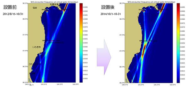
Fig. 2 Encounter frequency distribution of ships in the surrounding waters before (left) and after (right) installation of offshore facilities